Assessing the potential of soil moisture measurements for regional landslide early warning
- Wicki, Adrian Swiss Federal Institute for Forest, Snow and Landscape Research WSL, Zürcherstrasse 111, 8903, Birmensdorf, Switzerland
- Lehmann, Peter Institute of Biogeochemistry and Pollutant Dynamics, ETH Zurich, Universitätsstrasse 16, 8092, Zürich, Switzerland
- Hauck, Christian Department of Geosciences, University of Fribourg, Chemin du Musée 4, 1700, Fribourg, Switzerland
- Seneviratne, Sonia I. Institute for Atmospheric and Climate Science, ETH Zurich, Universitätsstrasse 16, 8092, Zürich, Switzerland
- Waldner, Peter Swiss Federal Institute for Forest, Snow and Landscape Research WSL, Zürcherstrasse 111, 8903, Birmensdorf, Switzerland
- Stähli, Manfred Swiss Federal Institute for Forest, Snow and Landscape Research WSL, Zürcherstrasse 111, 8903, Birmensdorf, Switzerland
-
15.04.2020
Published in:
- Landslides. - 2020, vol. 17, no. 8, p. 1881-1896
English
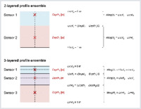
In mountainous terrain, rainfall-induced landslides pose a serious risk to people and infrastructure. Regional landslide early warning systems (LEWS) have proven to be a cost-efficient tool to inform the public about the imminent landslide danger. While most operational LEWS are based on rainfall exceedance thresholds only, recent studies have demonstrated an improvement of the forecast quality after the inclusion of soil hydrological information. In this study, the potential of in situ soil moisture measurements for regional landslide early warning is assessed. For the first time, a comprehensive soil moisture measurement database was compiled for Switzerland and compared with a national landslide database (Swiss flood and landslide damage database, WSL). The time series were homogenized and normalized to represent saturation values. From ensembles of sensors, the mean and standard deviation saturation were calculated and infiltration events were delimited, characterized, and classified as landslide-triggering or non-triggering based on the occurrence of landslides within a specified forecast distance. A logistic regression function was applied to model the landslide activity based on the infiltration event characteristics and several models were analysed and compared with receiver operating characteristics (ROC). A strong distance dependence becomes apparent showing a forecast goodness decrease with increasing distance between water content measurement site and landslide, and a better forecast goodness for long-lasting as opposed to short-duration precipitation events. While most variability can be explained by the two event properties antecedent saturation and change of saturation during an infiltration event, event properties that describe antecedent conditions are more important for long-lasting as opposed to short-duration precipitation events that can be better explained by properties describing event dynamics. Overall, the analysis demonstrated that in situ soil moisture data effectively contains specific information useful for landslide early warning.
- Faculty
- Faculté des sciences et de médecine
- Department
- Département de Géosciences
- Language
-
- English
- Classification
- Geology
- License
-
License undefined
- Identifiers
-
- RERO DOC 328431
- DOI 10.1007/s10346-020-01400-y
- Persistent URL
- https://folia.unifr.ch/unifr/documents/308430
Other files
Statistics
Document views: 225
File downloads:
- pdf: 329
- Supplementary material: 123